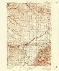
1935 Map of Pendleton
USGS Topo · Published 1935About this map
The Umatilla River valley and its surrounding dryland wheat country are recorded here in the mid-1930s, showing a landscape defined by the intersection of the Union Pacific railroad and the Old Oregon Trail. The city of Pendleton serves as the regional hub, flanked by the State Hospital and a local Landing Field. To the east, the Umatilla Indian Reservation contains a concentration of social and religious history, including the Umatilla Indian Agency, Mission St Andrews, and the Presbyterian Mission.
Find a feature on this map
92 named features on this map. Tap any name to fly to it.
Don’t see what you’re looking for? This feature index may not catch every label — zoom into the map to look around manually.
Map Details
Editions of this 1935 Pendleton Map
3 editions found
Other maps of this area

1908 · Umatilla
USGS Topo · 1:125,000

1915 · Wallulah
USGS Topo · 1:96,000

1917 · Pasco
USGS Topo · 1:125,000

1918 · Wallula
USGS Topo · 1:125,000

1919 · Walla Walla
USGS Topo · 1:125,000

1921 · Walla Walla
USGS Topo · 1:125,000

1935 · Pendleton
USGS Topo · 1:125,000

1953 · Pendleton
USGS Topo · 1:250,000

1953 · Walla Walla
USGS Topo · 1:250,000

1956 · Pendleton
USGS Topo · 1:250,000