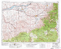
1953 Map of Pendleton
USGS Topo · Published 1975About this map
The Blue Mountains define the southeastern quadrant of this region, where the Umatilla Indian Reservation meets the dense timber of the Umatilla National Forest. This mid-century landscape is anchored by the Columbia River to the north, which serves as a vital artery for the agricultural and industrial towns of Umatilla, Irrigon, and Boardman. The interior reflects a specialized military and transport economy, dominated by the massive Umatilla Ordnance Depot and the sprawling Boardman Bombing Range.
Find a feature on this map
86 named features on this map. Tap any name to fly to it.
Don’t see what you’re looking for? This feature index may not catch every label — zoom into the map to look around manually.
Map Details
Editions of this 1953 Pendleton Map
4 editions found

Other maps of this area

1901 · Baker City
USGS Topo · 1:125,000

1901 · Sumpter
USGS Topo · 1:125,000

1906 · Telocaset
USGS Topo · 1:125,000

1906 · Blalock Island
USGS Topo · 1:125,000

1908 · Blalock Island
USGS Topo · 1:125,000

1908 · Umatilla
USGS Topo · 1:125,000

1910 · Zillah
USGS Topo · 1:125,000

1915 · Wallulah
USGS Topo · 1:96,000

1915 · Prosser
USGS Topo · 1:125,000

1916 · Arlington
USGS Topo · 1:125,000