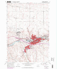
1966 Map of Pendleton
USGS Topo · Published 1978About this map
The Umatilla River cuts through the heart of this high desert region, serving as the central axis for the development of Pendleton. This 1960s survey captures the city during a period of significant suburban expansion, evidenced by the development of neighborhoods like Pendair Heights, West Hills, and Sherwood Heights. The infrastructure reflects a busy transportation and institutional hub, featuring the Municipal Airport to the northwest and the sprawling grounds of the Eastern Oregon State Hospital.
Find a feature on this map
45 named features on this map. Tap any name to fly to it.
Don’t see what you’re looking for? This feature index may not catch every label — zoom into the map to look around manually.
Map Details
Editions of this 1966 Pendleton Map
3 editions found
Other maps of this area

1935 · Pendleton
USGS Topo · 1:125,000

1953 · Pendleton
USGS Topo · 1:250,000

1956 · Pendleton
USGS Topo · 1:250,000

1966 · Mc Kay Reservoir
USGS Topo · 1:24,000

1966 · Holdman
USGS Topo · 1:24,000

1966 · Holdman SE
USGS Topo · 1:24,000

1966 · Table Rock
USGS Topo · 1:24,000

1966 · Pendleton
USGS Topo · 1:24,000

1966 · Mission
USGS Topo · 1:24,000
1966 · Helix
USGS Topo · 1:24,000