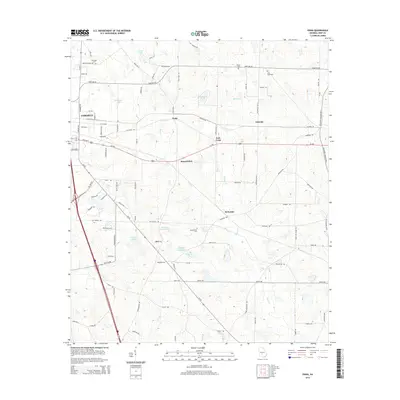
2014 Map of Penia
USGS Topo · Published 2014About this map
Cordele stands as the primary urban center on the western edge of this Crisp County landscape, while the interior is defined by agricultural lands and small rural settlements. The community of Penia sits at a central crossroads, surrounded by smaller localities including East Crisp, Listonia, and Musselwhite. The terrain is characterized by a network of creeks and man-made lakes, such as Eastwood Lake and the various basins of Williams Lake, which support the region's agricultural productivity. Family and community heritage is preserved in scattered burial grounds like Dorough Cem and Zion Hope Cem, located near the historic road networks. The intricate drainage patterns of Redoak Cr and Deep Cr navigate the gentle relief, illustrating the natural water management of the Georgia coastal plain. This 2014 survey documents the persistence of these named hamlets and the vital role of local water bodies in a modern southern rural context.
Find a feature on this map
93 named features on this map. Tap any name to fly to it.
Don’t see what you’re looking for? This feature index may not catch every label — zoom into the map to look around manually.
Map Details
Editions of this 2014 Penia Map
This is the sole edition of this map. No revisions or reprints were ever made.
Other maps of this area

1953 · Waycross
USGS Topo · 1:250,000

1957 · Macon
USGS Topo · 1:250,000

1958 · Macon
USGS Topo · 1:250,000

1958 · Waycross
USGS Topo · 1:250,000

1964 · Macon
USGS Topo · 1:250,000

1971 · Pineview West
USGS Topo · 1:24,000

1971 · Pineview SW
USGS Topo · 1:24,000
1972 · Vienna
USGS Topo · 1:24,000
1974 · Pitts
USGS Topo · 1:24,000

1974 · Amboy
USGS Topo · 1:24,000