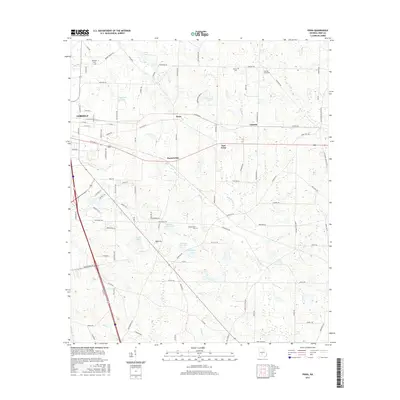
2017 Map of Penia
USGS Topo · Published 2017About this map
Agricultural lands and rural communities characterize this 2017 survey east of Cordele, where the landscape is defined by its small water bodies and historical family burial grounds. Significant local-history markers include Dorough Cem near Midway Church Rd and the Zion Hope Cem on Zion Hope Rd. The map documents a transition from the urban edge of Cordele into the unincorporated settlements of Penia, Listonia, and Musselwhite. A network of creeks and named lakes, such as Crane Lake, Matthews Lake, and the series of reservoirs known as Williams Lake Two and Williams Lake Three, indicates a reliance on water management for the surrounding farms. Roads like Old Penia Rd and Old Tremont RD connect these rural hubs, while the southern reaches are drained by Lime Cr and Reedy Br.
Find a feature on this map
101 named features on this map. Tap any name to fly to it.
Don’t see what you’re looking for? This feature index may not catch every label — zoom into the map to look around manually.
Map Details
Editions of this 2017 Penia Map
This is the sole edition of this map. No revisions or reprints were ever made.
Other maps of this area

1953 · Waycross
USGS Topo · 1:250,000

1957 · Macon
USGS Topo · 1:250,000

1958 · Macon
USGS Topo · 1:250,000

1958 · Waycross
USGS Topo · 1:250,000

1964 · Macon
USGS Topo · 1:250,000

1971 · Pineview West
USGS Topo · 1:24,000

1971 · Pineview SW
USGS Topo · 1:24,000
1972 · Vienna
USGS Topo · 1:24,000
1974 · Pitts
USGS Topo · 1:24,000

1974 · Amboy
USGS Topo · 1:24,000