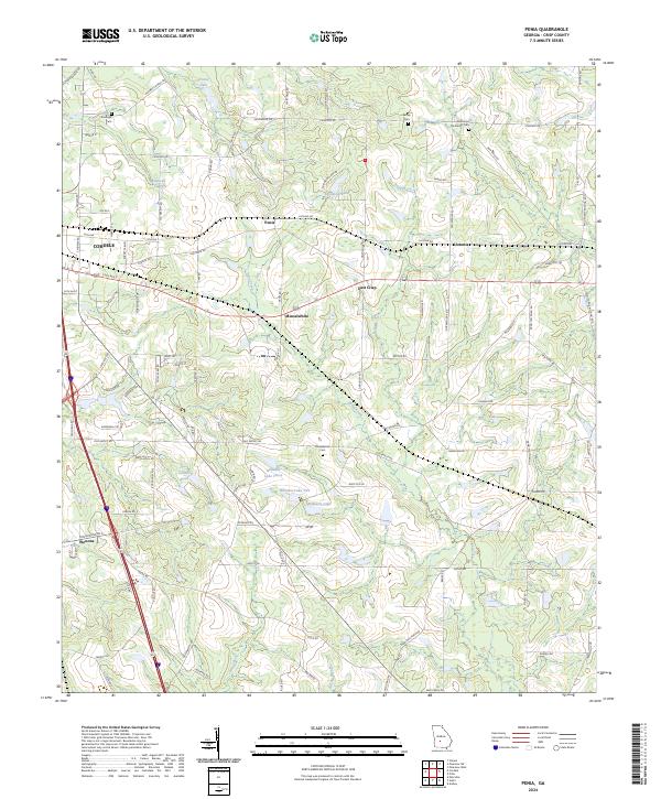
2024 Map of Penia
USGS Topo · Published 2024About this map
The agricultural landscape of Crisp County, Georgia, is defined by a network of small settlements and family-linked landmarks. Cordele occupies the northwestern corner, with its grid of avenues and streets transitioning into rural crossroads like Penia, Musselwhite, and East Crisp. The terrain is marked by significant water features including Crane Lake, Matthews Lake, and the meandering path of Redoak Creek. Historical depth is found in the distribution of community burial sites, from Dorough Cem in the north to the Zion Hope Methodist Cem near the eastern boundary. The presence of multiple water bodies such as Williams Lake Three and Carden Pond suggests a land-use pattern influenced by localized irrigation and water management, while the road network, including the historic Old Blackshear Rd, connects these small hubs across the coastal plain.
Find a feature on this map
105 named features on this map. Tap any name to fly to it.
Don’t see what you’re looking for? This feature index may not catch every label — zoom into the map to look around manually.
Map Details
Editions of this 2024 Penia Map
This is the sole edition of this map. No revisions or reprints were ever made.
Other maps of this area

1953 · Waycross
USGS Topo · 1:250,000

1957 · Macon
USGS Topo · 1:250,000

1958 · Macon
USGS Topo · 1:250,000

1958 · Waycross
USGS Topo · 1:250,000

1964 · Macon
USGS Topo · 1:250,000

1971 · Pineview West
USGS Topo · 1:24,000

1971 · Pineview SW
USGS Topo · 1:24,000
1972 · Vienna
USGS Topo · 1:24,000
1974 · Pitts
USGS Topo · 1:24,000

1974 · Amboy
USGS Topo · 1:24,000