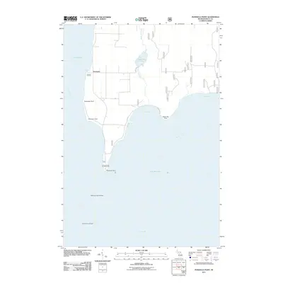
2011 Map of Peninsula Point
USGS Topo · Published 2011About this map
Stonington sits at the northern end of a narrow landmass dividing the waters of Little Bay de Noc and Big Bay de Noc. This peninsula, part of Delta County, terminates at the distinct Peninsula Point, where the Peninsula Point Recreation Area marks the convergence of these major arms of Green Bay. The landscape is defined by its maritime exposure, with coastal features such as Dutchman Point and Deepwater Point punctuating the shoreline. Inland, the hydrology is modest but significant for the local ecosystem, including Sandstrom Lake and the winding Wilsey Bay Creek. Navigational hazards like Peninsula Point Shoal and Eleven Foot Shoal extend into Lake Michigan, hinting at the area's maritime history. Local heritage is centered around sites like Lakeview Cemetery and the rural road network, including Swede 13 Rd, reflecting the settlement's cultural roots.
Find a feature on this map
19 named features on this map. Tap any name to fly to it.
Don’t see what you’re looking for? This feature index may not catch every label — zoom into the map to look around manually.
Map Details
Editions of this 2011 Peninsula Point Map
This is the sole edition of this map. No revisions or reprints were ever made.
Other maps of this area

1932 · Gladstone SE
USGS Topo · 1:31,680

1932 · Rapid River SE
USGS Topo · 1:31,680

1932 · Rapid River SW
USGS Topo · 1:31,680

1954 · Escanaba
USGS Topo · 1:250,000

1957 · Escanaba
USGS Topo · 1:250,000

1958 · Escanaba
USGS Topo · 1:250,000

1958 · Gladstone
USGS Topo · 1:62,500

1958 · Escanaba
USGS Topo · 1:62,500

1958 · Peninsula Point
USGS Topo · 1:62,500
1958 · Rapid River
USGS Topo · 1:62,500