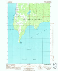
1985 Map of Peninsula Point
USGS Topo · Published 1985About this map
Peninsula Point Light House stands at the southern tip of a narrow finger of land, marking the division between Little Bay de Noc and Big Bay de Noc. This 1985 survey captures the rural character of the Stonington Peninsula, where much of the interior is protected within the Hiawatha National Forest. The settlement of Stonington serves as the primary community hub, supported by local landmarks like Trinity Ch and Lakeview Cem near the western shore.
Find a feature on this map
20 named features on this map. Tap any name to fly to it.
Don’t see what you’re looking for? This feature index may not catch every label — zoom into the map to look around manually.
Map Details
Editions of this 1985 Peninsula Point Map
This is the sole edition of this map. No revisions or reprints were ever made.
Other maps of this area

1932 · Gladstone SE
USGS Topo · 1:31,680

1932 · Rapid River SE
USGS Topo · 1:31,680

1932 · Rapid River SW
USGS Topo · 1:31,680

1954 · Escanaba
USGS Topo · 1:250,000

1957 · Escanaba
USGS Topo · 1:250,000

1958 · Escanaba
USGS Topo · 1:250,000

1958 · Gladstone
USGS Topo · 1:62,500

1958 · Escanaba
USGS Topo · 1:62,500

1958 · Peninsula Point
USGS Topo · 1:62,500
1958 · Rapid River
USGS Topo · 1:62,500