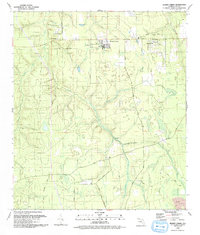
1993 Map of Penney Farms
USGS Topo · Published 1993About this map
Penney Farms serves as the focal point for this landscape, exhibiting a structured layout that includes a Golf Course, a Water Tank, and nearby Penney Farms Cem. The surrounding rural territory is defined by the winding paths of Black Creek and the South Fork Black Creek, with an Old Railroad Grade cutting across the northern sections, signaling the area's older transportation infrastructure. Local community life is grounded in scattered congregations, including the First Baptist Ch, New Hope Ch, and Salem Ch, which sits adjacent to Salem Cem. To the east, Pass Station marks another small settlement node, while the southern boundary near Terrill Creek shows industrial activity at a Strip Mine. This survey preserves the detailed rural road network, from Thunder Road in the northwest to Sweet Moody Road and Hogarth Road further south.
Find a feature on this map
31 named features on this map. Tap any name to fly to it.
Don’t see what you’re looking for? This feature index may not catch every label — zoom into the map to look around manually.
Map Details
Editions of this 1993 Penney Farms Map
This is the sole edition of this map. No revisions or reprints were ever made.
Other maps of this area

1917 · Orange Park
USGS Topo · 1:62,500

1918 · Middleburg
USGS Topo · 1:62,500

1918 · Orange Park
USGS Topo · 1:62,500

1941 · Middleburg
USGS Topo · 1:62,500

1942 · Ates Creek
USGS Topo · 1:62,500

1947 · Bostwick
USGS Topo · 1:50,000

1948 · Jacksonville
USGS Topo · 1:250,000

1949 · Rice Creek
USGS Topo · 1:24,000

1949 · Bostwick
USGS Topo · 1:24,000

1949 · Middleburg SW
USGS Topo · 1:24,000