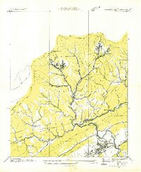
1935 Map of Pennington Gap
USGS Topo · Published 1935About this map
Pennington Gap sits at the southern edge of this mid-1930s survey, marking a vital junction for the L and N and Southern railroads along the Powell River. The map reveals an intensive industrial landscape carved into the slopes of Little Black Mountain and Stone Mountain, where a network of tramways and conveyors connects remote coal operations like Bonny Blue, Mayflower, and Benedict to the rail lines below. This era of extraction is balanced by a dense distribution of rural community life within the Jefferson National Forest, including the Leona Mines PO and several local schools such as Belgium Sch and Puckett Sch. The terrain is characterized by sharp ridges like Poor Valley Ridge and landmarks such as Nigger Head Rock and Hanging Rock, illustrating the difficult geography that governed the development of Virginia's coal country.
Find a feature on this map
52 named features on this map. Tap any name to fly to it.
Don’t see what you’re looking for? This feature index may not catch every label — zoom into the map to look around manually.
Map Details
Editions of this 1935 Pennington Gap Map
This is the sole edition of this map. No revisions or reprints were ever made.
Other maps of this area

1887 · Jonesville
USGS Topo · 1:125,000

1891 · Jonesville
USGS Topo · 1:125,000

1894 · Estillville
USGS Topo · 1:125,000

1916 · Nolansburg
USGS Topo · 1:48,000

1919 · Nolansburg
USGS Topo · 1:62,500

1921 · Big Stone Gap
USGS Topo · 1:48,000

1922 · Big Stone Gap
USGS Topo · 1:62,500

1929 · Big Stone Gap
USGS Topo · 1:62,500

1935 · Hubbard Springs
USGS Topo · 1:24,000
1935 · Evarts
USGS Topo · 1:24,000