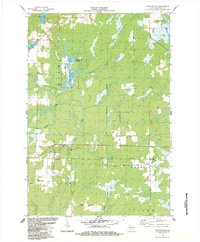
1984 Map of Pennington
USGS Topo · Published 1984About this map
Pennington sits at the eastern edge of this landscape where the Soo Line railroad cuts a straight path through the wooded terrain of Price County. The area is defined by its complex hydrology and managed conservation lands, notably the State Wildlife Area and the Spring Creek Flowage. The Jump River and its North Fork Cranberry Creek tributary wind through a mosaic of wetlands and timbered sections, reflecting a rural economy tied to the land and the rails. Local navigation is marked by distinctive corridor names like Moonshine Alley and Aspen Road, while the Fourth Principal Meridian serves as a critical surveying benchmark for the region. Small-scale industry is present through scattered Gravel Pits, and recreational access is noted at Wayside Park and various Public Access points along the lakes and riverbanks.
Find a feature on this map
26 named features on this map. Tap any name to fly to it.
Don’t see what you’re looking for? This feature index may not catch every label — zoom into the map to look around manually.
Map Details
Editions of this 1984 Pennington Map
This is the sole edition of this map. No revisions or reprints were ever made.
Other maps of this area

1941 · Kennan
USGS Topo · 1:48,000

1941 · Phillips
USGS Topo · 1:48,000

1943 · Philliips
USGS Topo · 1:48,000

1944 · Ogema
USGS Topo · 1:48,000

1945 · Kennan
USGS Topo · 1:48,000

1945 · Black River
USGS Topo · 1:48,000

1947 · Ogema
USGS Topo · 1:48,000

1949 · Ogema
USGS Topo · 1:48,000

1949 · Jump River Fire Tower
USGS Topo · 1:48,000

1953 · Rice Lake
USGS Topo · 1:250,000