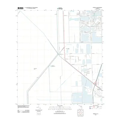
2012 Map of Pennsuco
USGS Topo · Published 2012About this map
The Miami Canal Number C-6 and its adjacent levees define the structured water management system of this South Florida region, including Levee 30 and Levee Number 33. In the southeast corner, the settlement of Pennsuco sits near the intersection of W Okeechobee Rd and Sysco Way, marking a pockets of industrial and transport activity. Further west, the landscape transitions into more open terrain where Draft Dodge Island and the L-67-C canal intersect. This 2012 survey illustrates the contrast between the expanding residential street grids of Miramar and the more utilitarian airfield at Opa Locka West Airport. Recreational sites like Thompson Park Campground and Jones Fishing Camp are situated along the primary canal routes, highlighting how the waterway network supports both infrastructure and local leisure in the Everglades buffer zone.
Find a feature on this map
60 named features on this map. Tap any name to fly to it.
Don’t see what you’re looking for? This feature index may not catch every label — zoom into the map to look around manually.
Map Details
Editions of this 2012 Pennsuco Map
This is the sole edition of this map. No revisions or reprints were ever made.
Other maps of this area

1949 · Opalocka
USGS Topo · 1:24,000

1950 · Hialeah
USGS Topo · 1:24,000

1956 · Miami
USGS Topo · 1:250,000

1956 · West Palm Beach
USGS Topo · 1:250,000

1957 · West Palm Beach
USGS Topo · 1:250,000

1958 · West Palm Beach
USGS Topo · 1:250,000

1958 · Miami
USGS Topo · 1:250,000
1962 · Hialeah
USGS Topo · 1:24,000

1962 · Opa-locka
USGS Topo · 1:24,000

1963 · Pennsuco
USGS Topo · 1:24,000