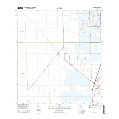
2015 Map of Pennsuco
USGS Topo · Published 2015About this map
Miami Canal and Pennsuco Canal define the hydrology of this South Florida corridor, where the residential expansion of Pembroke Pines and Miramar meets the industrial and agricultural fringes of Medley and Pennsuco. The landscape is a study in transition, with a rigid street grid emerging in the northeast while the southwest remains dominated by open land and large-scale water management features. Hialeah Gardens sits at a critical junction where major thoroughfares like W Okeechobee Rd and Krome Ave intersect the canal systems.
Find a feature on this map
45 named features on this map. Tap any name to fly to it.
Don’t see what you’re looking for? This feature index may not catch every label — zoom into the map to look around manually.
Map Details
Editions of this 2015 Pennsuco Map
This is the sole edition of this map. No revisions or reprints were ever made.
Other maps of this area

1949 · Opalocka
USGS Topo · 1:24,000

1950 · Hialeah
USGS Topo · 1:24,000

1956 · Miami
USGS Topo · 1:250,000

1956 · West Palm Beach
USGS Topo · 1:250,000

1957 · West Palm Beach
USGS Topo · 1:250,000

1958 · West Palm Beach
USGS Topo · 1:250,000

1958 · Miami
USGS Topo · 1:250,000
1962 · Hialeah
USGS Topo · 1:24,000

1962 · Opa-locka
USGS Topo · 1:24,000

1963 · Pennsuco
USGS Topo · 1:24,000