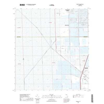
2018 Map of Pennsuco
USGS Topo · Published 2018About this map
The Everglades dominates the western portion of this 2018 survey, appearing as a vast, wetland landscape punctuated by landmarks like Draft Dodge Island and The Pocket. The map captures the sharp boundary where the conservation areas of the glades meet the expanding urban grid of South Florida. To the east, the sprawling residential developments of Pembroke Pines and Miramar are shown in high detail, with extensive man-made water features and complex street networks like Miramar Pkwy. The drainage and water management history of the region is evident through the prominent Miami Canal, Snake Creek Canal, and Pennsuco Canal, which cut linear paths through the terrain. In the southeast corner, industrial and suburban interfaces are visible near Pennsuco, Medley, and Hialeah Gardens, where major thoroughfares such as N Okeechobee Rd and Krome Ave serve as primary transit corridors.
Find a feature on this map
70 named features on this map. Tap any name to fly to it.
Don’t see what you’re looking for? This feature index may not catch every label — zoom into the map to look around manually.
Map Details
Editions of this 2018 Pennsuco Map
This is the sole edition of this map. No revisions or reprints were ever made.
Other maps of this area

1949 · Opalocka
USGS Topo · 1:24,000

1950 · Hialeah
USGS Topo · 1:24,000

1956 · Miami
USGS Topo · 1:250,000

1956 · West Palm Beach
USGS Topo · 1:250,000

1957 · West Palm Beach
USGS Topo · 1:250,000

1958 · West Palm Beach
USGS Topo · 1:250,000

1958 · Miami
USGS Topo · 1:250,000
1962 · Hialeah
USGS Topo · 1:24,000

1962 · Opa-locka
USGS Topo · 1:24,000

1963 · Pennsuco
USGS Topo · 1:24,000