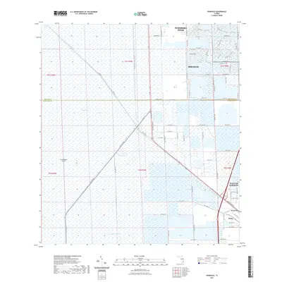
2021 Map of Pennsuco
USGS Topo · Published 2021About this map
The Everglades dominate the western portion of this landscape, where the vast marshland meets the encroaching suburban fringes of South Florida. The transition from the natural wetland of The Pocket to the modern residential grids of Pembroke Pines and Miramar is marked by the engineered corridor of the Conservation Levee - L32/31 Trt. This massive infrastructure project separates the wild interior from the developed coastal plain, a defining characteristic of the region's 21st-century geography.
Find a feature on this map
84 named features on this map. Tap any name to fly to it.
Don’t see what you’re looking for? This feature index may not catch every label — zoom into the map to look around manually.
Map Details
Editions of this 2021 Pennsuco Map
This is the sole edition of this map. No revisions or reprints were ever made.
Other maps of this area

1949 · Opalocka
USGS Topo · 1:24,000

1950 · Hialeah
USGS Topo · 1:24,000

1956 · Miami
USGS Topo · 1:250,000

1956 · West Palm Beach
USGS Topo · 1:250,000

1957 · West Palm Beach
USGS Topo · 1:250,000

1958 · West Palm Beach
USGS Topo · 1:250,000

1958 · Miami
USGS Topo · 1:250,000
1962 · Hialeah
USGS Topo · 1:24,000

1962 · Opa-locka
USGS Topo · 1:24,000

1963 · Pennsuco
USGS Topo · 1:24,000