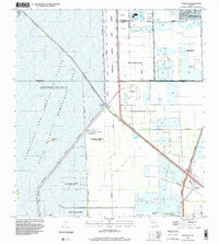
1994 Map of Pennsuco
USGS Topo · Published 2000About this map
The Everglades and Francis S Taylor Wildlife Management Area dominates the western half of this Florida landscape, where water is periodically impounded for conservation. In the mid-1990s, the boundary between Dade and Broward counties cut through a region transitioning from raw wetland to heavy industrial and suburban use. To the east, the Opa-Locka West Airport and numerous Quarries reflect the intensive land use of the era, while the small settlement of Pennsuco sits near the junction of Floridas Turnpike and the Miami Canal. This period of development is marked by the construction of the East Coast Buffer and the Everglades Buffer Strip, designed to separate the expanding suburban footprints of Pembroke Pines and Miramar from the delicate ecosystems of The Pocket.
Find a feature on this map
30 named features on this map. Tap any name to fly to it.
Don’t see what you’re looking for? This feature index may not catch every label — zoom into the map to look around manually.
Map Details
Editions of this 1994 Pennsuco Map
This is the sole edition of this map. No revisions or reprints were ever made.
Other maps of this area

1949 · Opalocka
USGS Topo · 1:24,000

1950 · Hialeah
USGS Topo · 1:24,000

1956 · Miami
USGS Topo · 1:250,000

1956 · West Palm Beach
USGS Topo · 1:250,000

1957 · West Palm Beach
USGS Topo · 1:250,000

1958 · West Palm Beach
USGS Topo · 1:250,000

1958 · Miami
USGS Topo · 1:250,000
1962 · Hialeah
USGS Topo · 1:24,000

1962 · Opa-locka
USGS Topo · 1:24,000

1963 · Pennsuco
USGS Topo · 1:24,000