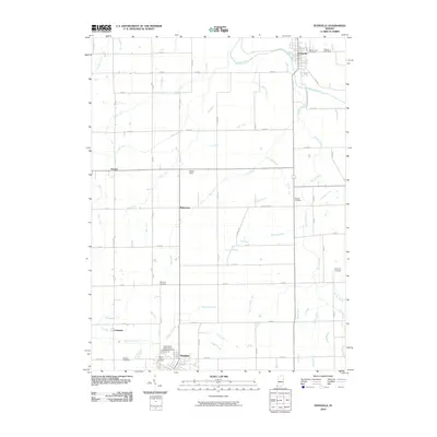
2010 Map of Pennville
USGS Topo · Published 2010About this map
Pennville and Dunkirk anchor this agricultural region of Jay County, where the landscape is defined by the winding Salamonie River and an extensive network of drainage ditches and runs. The area is notable for its numerous small burial grounds that dot the countryside, including the Independent Order of Odd Fellows Cemetery and Mount Tabor Cemetery near the southern boundary, alongside the Wayman Cemetery, Claycomb Cemetery, and Winters Cemetery further north. Smaller crossroads and settlements like Ridertown, Trenton, and Converse are linked by a precise grid of county roads. The drainage systems, such as Brooks Creek, Big Lick Creek, and Mud Creek, reflect the concerted effort to manage the local hydrology for farming. Named landmarks like Kesler Field and the Maple Lawn Cemetery near the Salamonie provide specific points of reference for local historians and genealogists tracing the development of these Indiana communities.
Find a feature on this map
73 named features on this map. Tap any name to fly to it.
Don’t see what you’re looking for? This feature index may not catch every label — zoom into the map to look around manually.
Map Details
Editions of this 2010 Pennville Map
This is the sole edition of this map. No revisions or reprints were ever made.
Other maps of this area

1953 · Muncie
USGS Topo · 1:250,000

1956 · Muncie
USGS Topo · 1:250,000

1960 · Pennville
USGS Topo · 1:24,000

1960 · Hartford City East
USGS Topo · 1:24,000

1960 · Blaine
USGS Topo · 1:24,000

1960 · Eaton
USGS Topo · 1:24,000

1960 · Ridgeville
USGS Topo · 1:24,000
1960 · Redkey
USGS Topo · 1:24,000

1962 · Montpelier
USGS Topo · 1:24,000

1962 · Petroleum
USGS Topo · 1:24,000