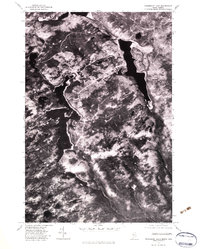
1977 Map of Penobscot Lake
USGS Topo · Published 1983About this map
Penobscot Lake dominates the center of this remote Somerset County landscape, recorded through a 1977 orthophotograph. This high-altitude perspective captures the complex shoreline of the lake and its neighboring waters, including Lac Du Portage to the northwest. The terrain is defined by dense forest cover and a network of drainage systems, such as Penobscot Brook and Mud Brook, which weave through the timberland. Smaller isolated water bodies like Cheney Pond and Mary Petuche Pond appear as dark pockets against the varied texture of the Maine woods. Unlike traditional line-drawn maps, this orthophotoquad preserves the literal visual state of the vegetation and hydrology as they existed in the late 1970s, providing researchers with an unfiltered view of the region's wilderness character.
Find a feature on this map
6 named features on this map. Tap any name to fly to it.
Don’t see what you’re looking for? This feature index may not catch every label — zoom into the map to look around manually.
Map Details
Editions of this 1977 Penobscot Lake Map
This is the sole edition of this map. No revisions or reprints were ever made.
Other maps of this area

1927 · Sandy Bay
USGS Topo · 1:48,000

1930 · Sandy Bay
USGS Topo · 1:62,500

1944 · Sandy Bay
USGS Topo · 1:62,500

1949 · Jackman
USGS Topo · 1:250,000

1956 · Penobscot Lake
USGS Topo · 1:62,500

1957 · Norris Brook
USGS Topo · 1:62,500

1957 · Saint Zacharie
USGS Topo · 1:62,500

1962 · Quebec
USGS Topo · 1:250,000

1963 · Jackman
USGS Topo · 1:250,000

1966 · Sherbrooke
USGS Topo · 1:250,000