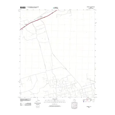
2010 Map of Penwell
USGS Topo · Published 2010About this map
Penwell and the surrounding Ector County oil lands appear here in this 2010 survey, reflecting the industrial character of West Texas. The landscape is defined by its transit and energy infrastructure, notably along the corridor of W Ave G and the rail line passing through Badger. The intersection of regional transit and local ranching interests is evident in the presence of the C-Bar Ranch, where specialized routes like C-Bar Ranch Rd and C Bar Rd connect the vast rangelands to the modern highway system. Industrial legacy is underscored by the presence of S Texaco Plant Rd, pointing toward the region's historical role in petroleum production. Further south, the map details the branching network of Henderson Rd and Ranch Rd 1601, illustrating how contemporary development in the Permian Basin integrates with long-established ranching boundaries.
Find a feature on this map
10 named features on this map. Tap any name to fly to it.
Don’t see what you’re looking for? This feature index may not catch every label — zoom into the map to look around manually.
Map Details
Editions of this 2010 Penwell Map
This is the sole edition of this map. No revisions or reprints were ever made.
Other maps of this area

1954 · Pecos
USGS Topo · 1:250,000

1957 · Pecos
USGS Topo · 1:250,000

1964 · Odessa SW
USGS Topo · 1:24,000

1964 · Douro
USGS Topo · 1:24,000

1964 · Metz
USGS Topo · 1:24,000

1964 · Red Lakes
USGS Topo · 1:24,000

1964 · Doodle Bug Well
USGS Topo · 1:24,000

1964 · Penwell SW
USGS Topo · 1:24,000

1964 · Penwell
USGS Topo · 1:24,000

1964 · Penwell SE
USGS Topo · 1:24,000