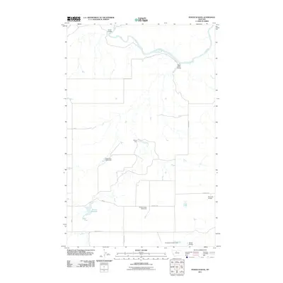
2011 Map of Penzer School
USGS Topo · Published 2011About this map
The Marias River carves a winding path across the northern reaches of this Hill County landscape, where the high plains are deeply etched by drainage coulees. This rural area, defined by its water management for ranching and agriculture, features a network of small reservoirs and containment structures such as Penzer Dam, Romain Reservoir, and the uniquely named Night Fever School Dam. The presence of the Penzer School (Historical) near Goosebill Rd serves as a reminder of the early 20th-century rural education system that once served the families of this remote region. The terrain is characterized by steep-sided draws including Horse Coulee, Dead Indian Coulee, and Fourmile Coulee, which channel seasonal runoff toward the river. To the south, Squiggles Number 2 Dam and Lees Lake further illustrate the ongoing efforts to secure water in this semi-arid Montana environment.
Find a feature on this map
15 named features on this map. Tap any name to fly to it.
Don’t see what you’re looking for? This feature index may not catch every label — zoom into the map to look around manually.
Map Details
Editions of this 2011 Penzer School Map
This is the sole edition of this map. No revisions or reprints were ever made.
Other maps of this area

1954 · Shelby
USGS Topo · 1:250,000

1958 · Shelby
USGS Topo · 1:250,000
1964 · Day School SW
USGS Topo · 1:24,000

1969 · Dutch Henry Coulee
USGS Topo · 1:24,000

1970 · Circle Bridge
USGS Topo · 1:24,000

1970 · Penzer School
USGS Topo · 1:24,000
1970 · Dorner School
USGS Topo · 1:24,000

1970 · Poverty Coulee SE
USGS Topo · 1:24,000

1970 · Goose Bill Butte NW
USGS Topo · 1:24,000

1970 · Rocky Coulee SW
USGS Topo · 1:24,000