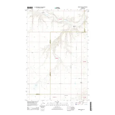
2014 Map of Penzer School
USGS Topo · Published 2014About this map
The Marias River carves a winding path across this northern Montana landscape, where the boundaries of Liberty, Hill, and Chouteau counties meet. The terrain is defined by a series of dramatic drainages, including Horse Coulee and Dead Indian Coulee in the north, which give way to the broad plateaus of the central quadrangle. Water management is central to this rural region, as evidenced by Romain Reservoir and Lees Lake. A grid of local roads, such as Goosebill Rd and Terra Firma Rd, provide access to the vast open sections. The map illustrates the intersection of natural hydrology and political divisions, showing how geographic features like Fourmile Coulee and Sheep Coulee define the physical character of these high plains counties.
Find a feature on this map
21 named features on this map. Tap any name to fly to it.
Don’t see what you’re looking for? This feature index may not catch every label — zoom into the map to look around manually.
Map Details
Editions of this 2014 Penzer School Map
This is the sole edition of this map. No revisions or reprints were ever made.
Other maps of this area

1954 · Shelby
USGS Topo · 1:250,000

1958 · Shelby
USGS Topo · 1:250,000
1964 · Day School SW
USGS Topo · 1:24,000

1969 · Dutch Henry Coulee
USGS Topo · 1:24,000

1970 · Circle Bridge
USGS Topo · 1:24,000

1970 · Penzer School
USGS Topo · 1:24,000
1970 · Dorner School
USGS Topo · 1:24,000

1970 · Poverty Coulee SE
USGS Topo · 1:24,000

1970 · Goose Bill Butte NW
USGS Topo · 1:24,000

1970 · Rocky Coulee SW
USGS Topo · 1:24,000