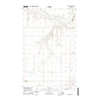
2017 Map of Penzer School
USGS Topo · Published 2017About this map
The Marias River carves a deep, winding path through this northern Montana landscape, where the borders of Hill, Liberty, and Chouteau counties converge. This high plains environment is defined by its dramatic drainage patterns, featuring the deeply incised Dead Indian Coulee and Horse Coulee that feed into the river valley. The map documents the rural infrastructure of the early 21st century, centered around the Penzer School location and a network of gravel roads including Goosebill Rd and the aptly named Teara Firma Rd. Water management for this semi-arid region is evident in landmarks like Romain Reservoir and Lees Lake. The area's character is shaped by large-scale agricultural divisions, with the grid-like Public Land Survey System overlaying the natural contours of Fourmile Coulee and Sheep Coulee.
Find a feature on this map
20 named features on this map. Tap any name to fly to it.
Don’t see what you’re looking for? This feature index may not catch every label — zoom into the map to look around manually.
Map Details
Editions of this 2017 Penzer School Map
This is the sole edition of this map. No revisions or reprints were ever made.
Other maps of this area

1954 · Shelby
USGS Topo · 1:250,000

1958 · Shelby
USGS Topo · 1:250,000
1964 · Day School SW
USGS Topo · 1:24,000

1969 · Dutch Henry Coulee
USGS Topo · 1:24,000

1970 · Circle Bridge
USGS Topo · 1:24,000

1970 · Penzer School
USGS Topo · 1:24,000
1970 · Dorner School
USGS Topo · 1:24,000

1970 · Poverty Coulee SE
USGS Topo · 1:24,000

1970 · Goose Bill Butte NW
USGS Topo · 1:24,000

1970 · Rocky Coulee SW
USGS Topo · 1:24,000