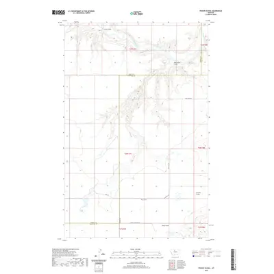
2020 Map of Penzer School
USGS Topo · Published 2020About this map
Penzer School stands as a lonely landmark within this sparsely populated landscape of north-central Montana, situated near the intersection of Goodsebill Rd and the local section lines. The terrain is deeply defined by the drainage systems feeding into the Marias River, which cuts across the northern reaches of the quadrangle. A series of dramatic coulees, including Horse Coulee, Dead Indian Coulee, and Fourmile Coulee, reveal the complex erosional patterns of the High Plains. To the southeast, the ephemeral Lees Lake provides a rare water catchment in a region otherwise dominated by large-scale agricultural blocks and gravel routes like Teara Firma Rd and Liberty Countyline Rd. The map illustrates the persistent grid of the Public Land Survey System, which dictates the placement of rural infrastructure and boundaries between Hill, Liberty, and Chouteau counties.
Find a feature on this map
19 named features on this map. Tap any name to fly to it.
Don’t see what you’re looking for? This feature index may not catch every label — zoom into the map to look around manually.
Map Details
Editions of this 2020 Penzer School Map
This is the sole edition of this map. No revisions or reprints were ever made.
Other maps of this area

1954 · Shelby
USGS Topo · 1:250,000

1958 · Shelby
USGS Topo · 1:250,000
1964 · Day School SW
USGS Topo · 1:24,000

1969 · Dutch Henry Coulee
USGS Topo · 1:24,000

1970 · Circle Bridge
USGS Topo · 1:24,000

1970 · Penzer School
USGS Topo · 1:24,000
1970 · Dorner School
USGS Topo · 1:24,000

1970 · Poverty Coulee SE
USGS Topo · 1:24,000

1970 · Goose Bill Butte NW
USGS Topo · 1:24,000

1970 · Rocky Coulee SW
USGS Topo · 1:24,000