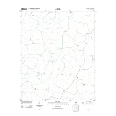
2012 Map of Peoples
USGS Topo · Published 2012About this map
Peoples and Silver Springs anchor this rural landscape in Tippah County, where the hydrology of the Hatchie River and the Little Hatchie River dictates the settlement pattern. The terrain is defined by low-lying wetlands like White Oak Bottom and prominent rises such as Williams Graveyard Hill and Silver Springs Hill. For the family historian, the map is particularly dense with burial sites and family-named landmarks, including the Peoples Cem and Richardson Cem. The presence of many small cemeteries—such as Spout Springs Cem, Medford Cem, and Rogers Chapel Cem—indicates a historically dispersed population of farming communities connected by a winding network of county roads. Small bridges like Waldon Bridge and Crum Bridge show where local commerce once crossed the creeks and branches feeding into the larger river systems.
Find a feature on this map
91 named features on this map. Tap any name to fly to it.
Don’t see what you’re looking for? This feature index may not catch every label — zoom into the map to look around manually.
Map Details
Editions of this 2012 Peoples Map
This is the sole edition of this map. No revisions or reprints were ever made.
Other maps of this area

1921 · Booneville
USGS Topo · 1:48,000

1922 · Booneville
USGS Topo · 1:62,500

1950 · Corinth
USGS Topo · 1:62,500

1951 · Walnut
USGS Topo · 1:62,500

1955 · Ripley
USGS Topo · 1:62,500

1956 · Tupelo
USGS Topo · 1:250,000

1958 · Tupelo
USGS Topo · 1:250,000

1972 · Jumpertown
USGS Topo · 1:24,000
1982 · Kossuth South
USGS Topo · 1:24,000
1982 · Dumas
USGS Topo · 1:24,000