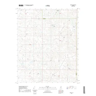
2018 Map of Peoples
USGS Topo · Published 2018About this map
The Little Hatchie River and Hatchie River converge in this corner of Tippah and Alcorn counties, creating a landscape defined by meandering creek beds and narrow ridges. The settlement of Peoples serves as a central point for a community largely connected by county roads like Co RD 200 and Co RD 500. This area is particularly rich in family and community burial grounds, preserving local history through sites such as Peoples Cem, Richardson Cem, Lebanon Cem, and Golden Hill Cem. Infrastructure in this rural river basin is highlighted by crossings like Waldon Bridge and Grum Bridge, while the topography is punctuated by prominent rises such as Silver Springs Hill and Neil Hill. The map provides a clear look at the distribution of homesteads and small family plots, such as Pleasant Ridge Cem and Lowrey Cem, that characterize the settlement patterns of northern Mississippi.
Find a feature on this map
92 named features on this map. Tap any name to fly to it.
Don’t see what you’re looking for? This feature index may not catch every label — zoom into the map to look around manually.
Map Details
Editions of this 2018 Peoples Map
This is the sole edition of this map. No revisions or reprints were ever made.
Other maps of this area

1921 · Booneville
USGS Topo · 1:48,000

1922 · Booneville
USGS Topo · 1:62,500

1950 · Corinth
USGS Topo · 1:62,500

1951 · Walnut
USGS Topo · 1:62,500

1955 · Ripley
USGS Topo · 1:62,500

1956 · Tupelo
USGS Topo · 1:250,000

1958 · Tupelo
USGS Topo · 1:250,000

1972 · Jumpertown
USGS Topo · 1:24,000
1982 · Kossuth South
USGS Topo · 1:24,000
1982 · Dumas
USGS Topo · 1:24,000