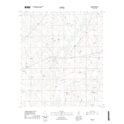
2018 Map of Peoria
USGS Topo · Published 2018About this map
Peoria and East Fork anchor this rural landscape in Amite County, where the network of family cemeteries provides a dense record of early local lineage. The terrain is defined by the winding course of the East Fork Amite River, which is fed by numerous tributaries including Gordon Cr, Gardner Cr, and Hominy Cr. The distribution of these burial grounds, such as Mount Sinai Cem, Brumfield-Whittington Cem, and Gardner-McKnight Cem, indicates a historical settlement pattern of dispersed farmsteads and small crossroads communities. In the eastern portion, Glading sits near the headwaters of Freshley Br, surrounded by several family plots like Quin Cem and Felder Cem. The land is crisscrossed by established local routes such as Old Peoria RD, N Greensburg RD, and E Fork RD, which historically linked these isolated clusters of residency and faith across the river's varied drainage basins.
Find a feature on this map
83 named features on this map. Tap any name to fly to it.
Don’t see what you’re looking for? This feature index may not catch every label — zoom into the map to look around manually.
Map Details
Editions of this 2018 Peoria Map
This is the sole edition of this map. No revisions or reprints were ever made.
Other maps of this area

1953 · Natchez
USGS Topo · 1:250,000

1956 · Natchez
USGS Topo · 1:250,000

1959 · Natchez
USGS Topo · 1:250,000

1961 · Liberty
USGS Topo · 1:62,500

1962 · Bude
USGS Topo · 1:62,500

1972 · Smithdale
USGS Topo · 1:24,000

1972 · Auburn
USGS Topo · 1:24,000

1972 · Peoria
USGS Topo · 1:24,000

1972 · Lake Tangipahoa
USGS Topo · 1:24,000
1972 · Gillsburg
USGS Topo · 1:24,000