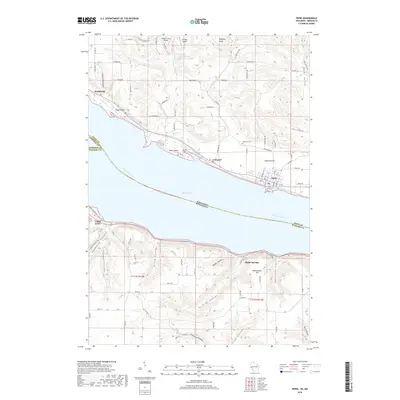
2018 Map of Pepin
USGS Topo · Published 2018About this map
Lake Pepin dominates this section of the Mississippi River corridor, where the water expands into its widest natural point between the bluffs of Wisconsin and Minnesota. The topography is defined by deeply carved coulees and high bluffs, such as Bogus Bluff and Hellsing Bluff, which create a striking vertical relief against the flat agricultural land of Pepin Prairie. The Wisconsin side shows a concentration of small settlements like Pepin, Stockholm, and Lakeport clustered along the shoreline and rail corridor, while the Minnesota side features the larger community of Lake City. Numerous family-named coulees, including Riley Coulee, King Coulee, and Marx Coulee, reveal the drainage patterns that have shaped the rural landscape and road networks for generations. The presence of Oakwood Cem and several landing strips like Airwolfe Airport illustrate the blend of historic land use and modern rural infrastructure.
Find a feature on this map
98 named features on this map. Tap any name to fly to it.
Don’t see what you’re looking for? This feature index may not catch every label — zoom into the map to look around manually.
Map Details
Editions of this 2018 Pepin Map
This is the sole edition of this map. No revisions or reprints were ever made.
Other maps of this area

1932 · Wabasha
USGS Topo · 1:62,500

1935 · Arkansaw
USGS Topo · 1:48,000

1940 · Maiden Rock
USGS Topo · 1:62,500

1941 · Arkansaw
USGS Topo · 1:62,500

1942 · Arkansaw
USGS Topo · 1:62,500

1950 · Maiden Rock
USGS Topo · 1:62,500

1951 · Wabasha
USGS Topo · 1:62,500

1951 · Lake City
USGS Topo · 1:62,500

1953 · Saint Paul
USGS Topo · 1:250,000

1959 · Saint Paul
USGS Topo · 1:250,000