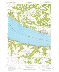
1974 Map of Pepin
USGS Topo · Published 1976About this map
Lake Pepin, a naturally occurring widening of the Mississippi River, dominates this mid-1970s survey of the Wisconsin-Minnesota border. The river valley is flanked by two distinct rail lines: the Burlington Northern running along the Wisconsin shore through Pepin and Stockholm, and the Chicago Milwaukee St Paul and Pacific tracing the Minnesota side past Lake City. The landscape is defined by the contrast between the flat Pepin Prairie and the deeply incised coulees of the Minnesota Memorial Hardwood State Forest. The topographic detail reveals a network of local drainages like Dutchman Coulee and Riley Coulee, which cut through the bluffs. Notable local landmarks include Oakwood Cem and the Landing Strip near the shoreline, providing a clear picture of the region's transportation and settlement patterns during this era.
Find a feature on this map
34 named features on this map. Tap any name to fly to it.
Don’t see what you’re looking for? This feature index may not catch every label — zoom into the map to look around manually.
Map Details
Editions of this 1974 Pepin Map
This is the sole edition of this map. No revisions or reprints were ever made.
Other maps of this area

1932 · Wabasha
USGS Topo · 1:62,500

1935 · Arkansaw
USGS Topo · 1:48,000

1940 · Maiden Rock
USGS Topo · 1:62,500

1941 · Arkansaw
USGS Topo · 1:62,500

1942 · Arkansaw
USGS Topo · 1:62,500

1950 · Maiden Rock
USGS Topo · 1:62,500

1951 · Wabasha
USGS Topo · 1:62,500

1951 · Lake City
USGS Topo · 1:62,500

1953 · Saint Paul
USGS Topo · 1:250,000

1959 · Saint Paul
USGS Topo · 1:250,000