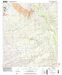
1996 Map of Peppersauce Wash
USGS Topo · Published 2003About this map
Industrial expansion and high-desert drainage define this Pinal County landscape, which transitions from the settlement of San Manuel in the northwest to the riparian corridor of the San Pedro River in the east. The map captures the significant environmental footprint of regional mining, notably the extensive area of Tailings and the presence of Sediment Tanks near the town center. Local geology is further emphasized by the Black Hills Mine and a central Pit located within the Black Hills.
Find a feature on this map
19 named features on this map. Tap any name to fly to it.
Don’t see what you’re looking for? This feature index may not catch every label — zoom into the map to look around manually.
Map Details
Editions of this 1996 Peppersauce Wash Map
This is the sole edition of this map. No revisions or reprints were ever made.
Other maps of this area

1904 · Tucson
USGS Topo · 1:125,000

1905 · Tucson
USGS Topo · 1:125,000

1911 · Winkelman
USGS Topo · 1:125,000

1913 · Winkelman
USGS Topo · 1:125,000

1938 · Galiuro Mts
USGS Topo · 1:48,000

1943 · Galiuro Mts
USGS Topo · 1:62,500

1945 · Redington
USGS Topo · 1:62,500

1948 · Clark Ranch
USGS Topo · 1:24,000

1948 · Mammoth
USGS Topo · 1:62,500

1948 · Mammoth
USGS Topo · 1:24,000