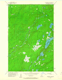
1956 Map of Pequaywan Lake
USGS Topo · Published 1963About this map
The Cloquet Valley State Forest dominates this landscape in St. Louis County, where complex hydrological networks define the north woods. The Pequaywan Lake basin is the central feature, surrounded by dozens of smaller water bodies including Moose Lake, Santa Claus Lake, and Wigwam Lake. This survey illustrates the intricate drainage patterns where the West Branch Cloquet River and the Little Cloquet River converge. The topography reveals a region of low-lying marshes and glacial depressions, largely within the civil townships of Ault and Alden. These 1950s records are particularly valuable for documenting the original shorelines and water levels of lakes like Marion Lake and Glenn Lake before modern development or environmental shifts altered their profiles. The map provides a detailed view of the remote road network and the isolation of these northern waters during the mid-century.
Find a feature on this map
27 named features on this map. Tap any name to fly to it.
Don’t see what you’re looking for? This feature index may not catch every label — zoom into the map to look around manually.
Map Details
Editions of this 1956 Pequaywan Lake Map
4 editions found
Other maps of this area

1954 · Barrs Lake
USGS Topo · 1:24,000

1954 · Thompson Lake
USGS Topo · 1:24,000

1954 · Mc Carthy Creek
USGS Topo · 1:24,000

1954 · Two Harbors
USGS Topo · 1:250,000

1954 · Hibbing
USGS Topo · 1:250,000

1956 · Pequaywan Lake
USGS Topo · 1:24,000

1956 · King Lake
USGS Topo · 1:24,000

1957 · Two Harbors
USGS Topo · 1:250,000

1957 · Hibbing
USGS Topo · 1:250,000

1957 · Brimson
USGS Topo · 1:62,500