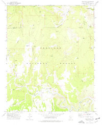
1973 Map of Perkinsville
USGS Topo · Published 1977About this map
The settlement of Perkinsville sits at the heart of this mid-1970s survey, marking a vital junction where the Atchison Topeka and Santa Fe railroad follows the winding course of the Verde River. The landscape is a complex network of canyons and draws, including Government Canyon and Bear Canyon, which define the borders between the Coconino National Forest and Prescott National Forest. Livestock ranching and resource extraction are evident through the numerous water catchments like Mexican Tank and Witty Tom Tank, alongside several Quarries and a Gravel Pit. To the northeast, the Sycamore Canyon Wilderness preserves the undisturbed terrain, while to the south, the river bends around Little Black Mesa and into the secluded Mormon Pocket. This map documents a specialized interior landscape where industrial transit and wilderness management coexist.
Find a feature on this map
51 named features on this map. Tap any name to fly to it.
Don’t see what you’re looking for? This feature index may not catch every label — zoom into the map to look around manually.
Map Details
Editions of this 1973 Perkinsville Map
2 editions found
Other maps of this area

1886 · Chino
USGS Topo · 1:250,000

1887 · Prescott
USGS Topo · 1:250,000

1891 · Chino
USGS Topo · 1:250,000

1892 · Prescott
USGS Topo · 1:250,000

1905 · Jerome
USGS Topo · 1:125,000

1922 · Williams
USGS Topo · 1:125,000

1944 · Clarkdale
USGS Topo · 1:48,000

1947 · Ash Fork
USGS Topo · 1:62,500

1947 · Paulden
USGS Topo · 1:62,500

1948 · Ash Fork
USGS Topo · 1:63,360