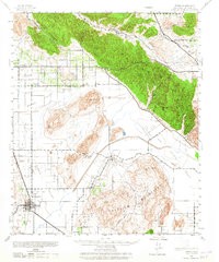
1942 Map of Perris
USGS Topo · Published 1965About this map
The agricultural plains of the Perris Valley and San Jacinto Valley define this landscape during a period of transition before post-war suburbanization. The central hub of Perris and the outlying settlement of Moreno are connected by a network of early roads such as Alessandro Boulevard and Ironwood Avenue. Water remains the critical factor for life in this arid basin, marked by El Casco Lake, Console Springs, and the Bernasconi Hot Springs near Bernasconi Pass.
Find a feature on this map
38 named features on this map. Tap any name to fly to it.
Don’t see what you’re looking for? This feature index may not catch every label — zoom into the map to look around manually.
Map Details
Editions of this 1942 Perris Map
2 editions found

Other maps of this area

1896 · San Bernardino
USGS Topo · 1:62,500

1898 · San Bernardino
USGS Topo · 1:62,500

1899 · Redlands
USGS Topo · 1:62,500

1901 · Southern California Sheet No. 1
USGS Topo · 1:250,000

1901 · San Jacinto
USGS Topo · 1:125,000

1901 · San Bernardino
USGS Topo · 1:62,500

1901 · Redlands
USGS Topo · 1:62,500

1901 · Elsinore
USGS Topo · 1:125,000

1901 · Riverside
USGS Topo · 1:62,500

1902 · San Gorgonio
USGS Topo · 1:125,000