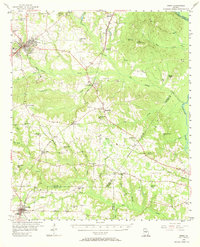
1956 Map of Perry
USGS Topo · Published 1968About this map
The Central of Georgia and Southern railroads anchor the development of central Georgia on this mid-1950s survey. The landscape transitions from the primary settlement of Perry south toward Unadilla, revealing a network of small agricultural communities and rural landmarks. Education and faith are central to the social fabric of the era, evidenced by numerous facilities such as the County Training Sch, Kings Chapel Sch, and Southside Sch, alongside churches like Memorial Heights Ch and Oak Level Ch.
Find a feature on this map
51 named features on this map. Tap any name to fly to it.
Don’t see what you’re looking for? This feature index may not catch every label — zoom into the map to look around manually.
Map Details
Editions of this 1956 Perry Map
2 editions found
Other maps of this area

1956 · Fort Valley
USGS Topo · 1:62,500

1956 · Cochran
USGS Topo · 1:62,500

1956 · Perry
USGS Topo · 1:62,500

1956 · Warner Robins
USGS Topo · 1:62,500

1956 · Jeffersonville
USGS Topo · 1:62,500

1957 · Macon
USGS Topo · 1:250,000

1958 · Macon
USGS Topo · 1:250,000

1964 · Macon
USGS Topo · 1:250,000

1971 · Pineview NW
USGS Topo · 1:24,000

1971 · Henderson
USGS Topo · 1:24,000