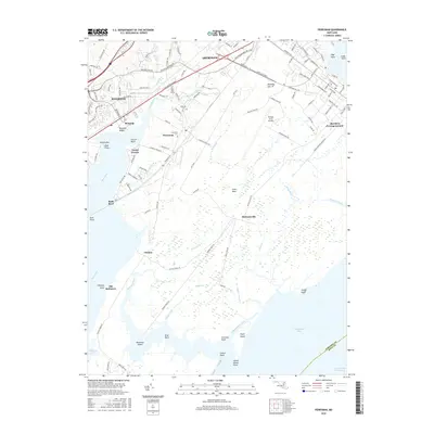
2016 Map of Perryman
USGS Topo · Published 2016About this map
The Aberdeen Proving Ground dominates the landscape of Harford County in this survey, showcasing the specialized military infrastructure of the early 21st century. The map details a complex grid of testing and training grounds, including the Trench Warfare Range Rd, Phillips Army Airfield, and specialized routes like Pistol Rd and Combat Rd. While the northern section around Aberdeen and Riverside shows modern suburban development, the coastal areas along the Bush River and Chesapeake Bay retain a distinctive tidal character. Here, small communities like Michaelsville and Chelsea sit amidst extensive wetlands and creek systems such as Romney Creek and Bridge Cr. For genealogists, the map preserves the locations of several historic burial sites, including Saint Paul Cem, Spesutie Cem, and Cranberry Cem, alongside the location of Old Baltimore near the water's edge.
Find a feature on this map
123 named features on this map. Tap any name to fly to it.
Don’t see what you’re looking for? This feature index may not catch every label — zoom into the map to look around manually.
Map Details
Editions of this 2016 Perryman Map
This is the sole edition of this map. No revisions or reprints were ever made.
Other maps of this area

1893 · Gunpowder
USGS Topo · 1:62,500

1898 · Tolchester
USGS Topo · 1:125,000

1900 · Havre De Grace
USGS Topo · 1:62,500

1900 · Betterton
USGS Topo · 1:62,500

1901 · Belair
USGS Topo · 1:62,500

1901 · Gunpowder
USGS Topo · 1:62,500

1903 · Tolchester
USGS Topo · 1:125,000

1908 · Tolchester
USGS Topo · 1:125,000

1941 · Gunpowder
USGS Topo · 1:62,500

1942 · Havre De Grace
USGS Topo · 1:62,500