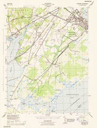
1944 Map of Perryman
USGS Topo · Published 1944About this map
The Aberdeen Proving Ground dominates the landscape of this 1944 War Department survey, reflecting the region's critical military importance during World War II. Large tracts of the Aberdeen Proving Ground Reservation Boundary encompass specialized facilities like the Balloon Tower APG, Airport Sta APG, and the Michaelsville Tank APG near the settlement of Michaelsville. These military installations sit alongside established civilian infrastructure, including the Baltimore and Ohio and Pennsylvania railroads which bisect the terrain.
Find a feature on this map
54 named features on this map. Tap any name to fly to it.
Don’t see what you’re looking for? This feature index may not catch every label — zoom into the map to look around manually.
Map Details
Editions of this 1944 Perryman Map
This is the sole edition of this map. No revisions or reprints were ever made.
Other maps of this area

1893 · Gunpowder
USGS Topo · 1:62,500

1898 · Tolchester
USGS Topo · 1:125,000

1900 · Havre De Grace
USGS Topo · 1:62,500

1900 · Betterton
USGS Topo · 1:62,500

1901 · Belair
USGS Topo · 1:62,500

1901 · Gunpowder
USGS Topo · 1:62,500

1903 · Tolchester
USGS Topo · 1:125,000

1908 · Tolchester
USGS Topo · 1:125,000

1941 · Gunpowder
USGS Topo · 1:62,500

1942 · Havre De Grace
USGS Topo · 1:62,500