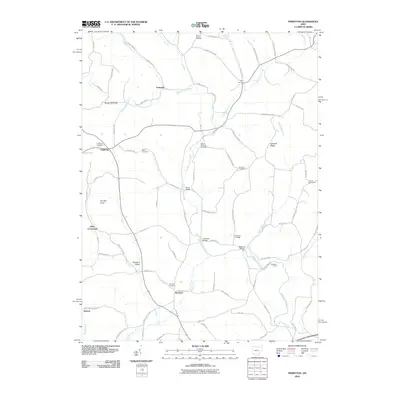
2010 Map of Perryton
USGS Topo · Published 2010About this map
Wakatomi ka Creek meanders through this portion of Licking and Coshocton Counties, anchoring a rural landscape defined by historic crossings and scattered settlements. Small communities like Fallsburg and Perryton serve as focal points for a network of township roads that follow the winding drainage patterns of Brushy Fork and Nickel Valley Run. The map provides significant genealogical value through its identification of numerous family and community burial grounds, including Meek Cemetery, Anderson Cemetery, and the Perry Chapel Cemetery near the northern boundary.
Find a feature on this map
86 named features on this map. Tap any name to fly to it.
Don’t see what you’re looking for? This feature index may not catch every label — zoom into the map to look around manually.
Map Details
Editions of this 2010 Perryton Map
This is the sole edition of this map. No revisions or reprints were ever made.
Other maps of this area

1909 · Newark
USGS Topo · 1:62,500
1910 · Frazeysburg
USGS Topo · 1:62,500

1912 · Gambier
USGS Topo · 1:62,500
1913 · Brinkhaven
USGS Topo · 1:62,500

1914 · Gambier
USGS Topo · 1:62,500
1915 · Brinkhaven
USGS Topo · 1:62,500
1943 · Gambier
USGS Topo · 1:62,500

1950 · Marion
USGS Topo · 1:250,000
1961 · Hanover
USGS Topo · 1:24,000
1961 · Walhonding
USGS Topo · 1:24,000