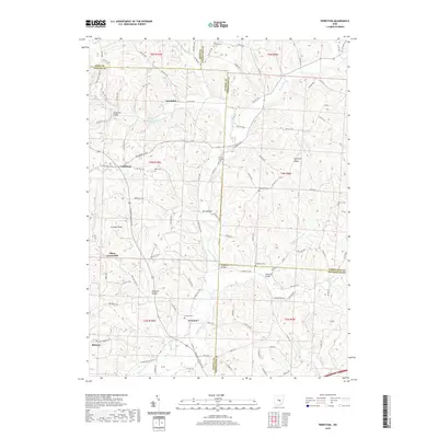
2019 Map of Perryton
USGS Topo · Published 2019About this map
Wakatamika Creek defines the local geography of this central Ohio landscape, where the borders of Licking, Coshocton, and Muskingum Counties converge. The settlement of Fallsburg sits at a crossroads in the west, while Perryton and Tilton Crossroads anchor the southern reaches. This modern survey illustrates a deeply rooted rural community, marked by numerous small burial grounds such as Perry Chapel Cem and the Robinson Cem that reflect generations of local families. Historical infrastructure remains central to the area's movement, including the Gregg Mill Bridge crossing Wakatomika Cr and the Patterson Bridge. Terrain features like Ashcraft Ridge and Fox Den Knob rise above the many winding waterways, including Nickel Valley Run and Brushy Fork, showing the complex drainage patterns that have shaped land use and road placement throughout the townships.
Find a feature on this map
105 named features on this map. Tap any name to fly to it.
Don’t see what you’re looking for? This feature index may not catch every label — zoom into the map to look around manually.
Map Details
Editions of this 2019 Perryton Map
This is the sole edition of this map. No revisions or reprints were ever made.
Other maps of this area

1909 · Newark
USGS Topo · 1:62,500

1910 · Frazeysburg
USGS Topo · 1:62,500

1912 · Gambier
USGS Topo · 1:62,500

1913 · Brinkhaven
USGS Topo · 1:62,500

1914 · Gambier
USGS Topo · 1:62,500

1915 · Brinkhaven
USGS Topo · 1:62,500

1943 · Gambier
USGS Topo · 1:62,500

1950 · Marion
USGS Topo · 1:250,000

1961 · Hanover
USGS Topo · 1:24,000
1961 · Walhonding
USGS Topo · 1:24,000