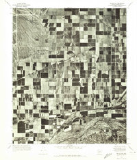
1971 Map of Perryville
USGS Topo · Published 1972About this map
Grid-patterned agricultural fields dominate this 1971 orthophotomosaic of the Maricopa County landscape. This specific type of aerial survey reveals the highly organized irrigation and land-use patterns essential for desert farming south of the White Tank Mountains. The small settlement of Perryville sits centrally within this geometric patchwork, while the community of Liberty anchors the southern boundary. The natural curves of the Gila River cut a distinct, irregular path across the bottom of the map, contrasting sharply with the man-made canals and roads that define the surrounding valley. This perspective provides an clear look at rural development and water management in the Salt River Valley just before the rapid suburban expansion of the late twentieth century reached this portion of the Arizona desert.
Find a feature on this map
3 named features on this map. Tap any name to fly to it.
Don’t see what you’re looking for? This feature index may not catch every label — zoom into the map to look around manually.
Map Details
Editions of this 1971 Perryville Map
This is the sole edition of this map. No revisions or reprints were ever made.
Other maps of this area

1946 · Avondale
USGS Topo · 1:62,500

1948 · Cashion
USGS Topo · 1:62,500

1954 · Phoenix
USGS Topo · 1:250,000

1957 · Phoenix
USGS Topo · 1:250,000

1957 · White Tank Mts. SE
USGS Topo · 1:24,000

1957 · Valencia
USGS Topo · 1:24,000

1957 · Perryville
USGS Topo · 1:24,000

1957 · El Mirage
USGS Topo · 1:24,000

1957 · Waddell
USGS Topo · 1:24,000

1957 · Tolleson
USGS Topo · 1:24,000