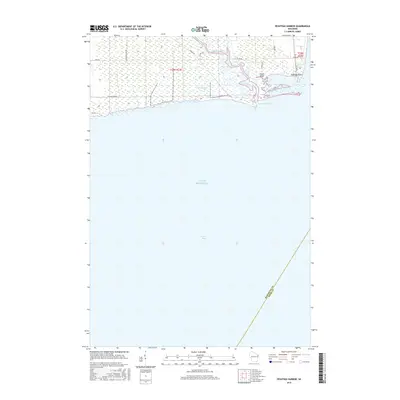
2015 Map of Peshtigo Harbor
USGS Topo · Published 2015About this map
The Peshtigo River meanders through coastal wetlands before emptying into the waters of Peshtigo Harbor in this 2015 U.S. Geological Survey representation of the Wisconsin shoreline. This aquatic landscape is defined by the complex network of Dyers Slough and the prominent Peshtigo Point, which separates the inner harbor from the expansive Green Bay and Lake Michigan. The map reveals a transition between state-managed lands and local transit, with the Wisconsin DNR Rd and Co Rd BB providing access to this marshy environment. The presence of the Slough Bridge and various local lanes like Canal Ln and Spitzmacher Rd indicates the area's utility for both conservation and local recreation. A prominent boundary line also marks the maritime division between Marinette Co and Door Co across the bay.
Find a feature on this map
21 named features on this map. Tap any name to fly to it.
Don’t see what you’re looking for? This feature index may not catch every label — zoom into the map to look around manually.
Map Details
Editions of this 2015 Peshtigo Harbor Map
This is the sole edition of this map. No revisions or reprints were ever made.
Other maps of this area

1939 · Marinette
USGS Topo · 1:48,000

1939 · Porterfield
USGS Topo · 1:48,000

1942 · Porterfield
USGS Topo · 1:48,000

1954 · Escanaba
USGS Topo · 1:250,000

1954 · Manitowoc
USGS Topo · 1:250,000

1956 · Oconto
USGS Topo · 1:62,500

1957 · Escanaba
USGS Topo · 1:250,000

1958 · Escanaba
USGS Topo · 1:250,000

1958 · Manitowoc
USGS Topo · 1:250,000

1961 · Little Sturgeon
USGS Topo · 1:62,500