
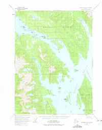
1951 Map of Petersburg A-1
USGS Topo · Published 1968About this map
Zimovia Strait separates the coastal stretches of Wrangell Island and Etolin Island in this mid-century survey of the Alexander Archipelago. The maritime character of the region is evident in the cluster of Village Islands and the small settlement of Village along the northern shore. Further south, the map documents remote encampments marked simply as Cabins and provides detail on sheltered waterways like Fisherman Chuck and Canoe Passage.
Find a feature on this map
33 named features on this map. Tap any name to fly to it.
Don’t see what you’re looking for? This feature index may not catch every label — zoom into the map to look around manually.
Map Details
Editions of this 1951 Petersburg A-1 Map
2 editions found
Other maps of this area

1948 · Petersburg A-1
USGS Topo · 1:63,360

1948 · Petersburg A-2
USGS Topo · 1:63,360

1948 · Petersburg B-2
USGS Topo · 1:63,360

1948 · Petersburg B-1
USGS Topo · 1:63,360

1949 · Craig D-2
USGS Topo · 1:63,360

1949 · Craig D-1
USGS Topo · 1:63,360

1951 · Craig D-2
USGS Topo · 1:63,360

1951 · Bradfield Canal
USGS Topo · 1:250,000

1951 · Craig D-1
USGS Topo · 1:63,360

1952 · Petersburg
USGS Topo · 1:250,000