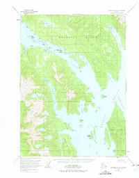
1951 Map of Petersburg A-1
USGS Topo · Published 1975About this map
Wrangell Island and Etolin Island dominate this coastal survey of the Tongass National Forest, separated by the deep waters of Zimovia Strait. The maritime character of the region is evident in the network of sheltered waterways, from the narrow Menefee Inlet to the sprawling Ernest Sound. Evidence of human activity is concentrated along the shorelines, marked by Village Islands and Village Islets, alongside scattered Cabins at Olive Cove. Significant peaks like Mt Etolin and Mt Shakes provide dramatic relief above the complex system of tidal flats and inlets. The map illustrates a wilderness landscape where transportation is dictated by the tides, particularly through passages like Canoe Passage and protected anchorages such as Whale-tail Cove.
Find a feature on this map
33 named features on this map. Tap any name to fly to it.
Don’t see what you’re looking for? This feature index may not catch every label — zoom into the map to look around manually.
Map Details
Editions of this 1951 Petersburg A-1 Map
2 editions found
Other maps of this area

1948 · Petersburg A-1
USGS Topo · 1:63,360

1948 · Petersburg A-2
USGS Topo · 1:63,360

1948 · Petersburg B-2
USGS Topo · 1:63,360

1948 · Petersburg B-1
USGS Topo · 1:63,360

1949 · Craig D-2
USGS Topo · 1:63,360

1949 · Craig D-1
USGS Topo · 1:63,360

1951 · Craig D-2
USGS Topo · 1:63,360

1951 · Bradfield Canal
USGS Topo · 1:250,000

1951 · Craig D-1
USGS Topo · 1:63,360

1951 · Petersburg A-1
USGS Topo · 1:63,360