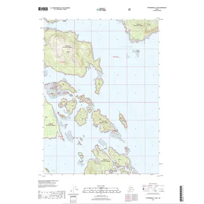
2017 Map of Petersburg A-3 NW
USGS Topo · Published 2017About this map
Tongass National Forest encompasses the entirety of this coastal Alaskan landscape, where the waters of the Gulf of Alaska meet a complex network of islands and passages. The archipelago is dominated by the Kashevarof Islands and the Blashke Islands, separated from larger landmasses by the Kashevarof Passage. Topographic detail reveals the steep, wooded terrain of Zarembo Island and Shrubby Island, punctuated by navigational landmarks like Point Nesbitt and the treacherous Nesbitt Reef. The map illustrates a wilderness defined by water, where named channels like Ossipee Channel provide the only thoroughfares through the scattered outcrops. This 2017 survey shows the intricate shoreline of the Wrangell Borough boundary, tracing a maritime environment where isolated features like Bluff Island and Middle Islands remain largely untouched by development.
Find a feature on this map
18 named features on this map. Tap any name to fly to it.
Don’t see what you’re looking for? This feature index may not catch every label — zoom into the map to look around manually.
Map Details
Editions of this 2017 Petersburg A-3 NW Map
This is the sole edition of this map. No revisions or reprints were ever made.
Other maps of this area

1948 · Petersburg B-3
USGS Topo · 1:63,360

1949 · Petersburg A-3
USGS Topo · 1:63,360

1949 · Petersburg A-4
USGS Topo · 1:63,360

1949 · Petersburg B-4
USGS Topo · 1:63,360

1951 · Petersburg B-4
USGS Topo · 1:63,360

1951 · Petersburg B-3
USGS Topo · 1:63,360

1952 · Petersburg
USGS Topo · 1:250,000

1953 · Petersburg A-4
USGS Topo · 1:63,360

1953 · Petersburg A-3
USGS Topo · 1:63,360

1960 · Petersburg
USGS Topo · 1:250,000