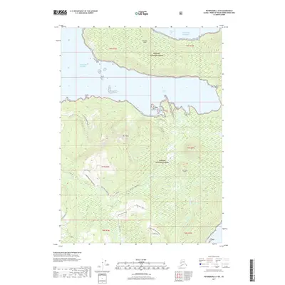
2017 Map of Petersburg A-5 SW
USGS Topo · Published 2017About this map
Kosciusko Island dominates this portion of the Alexander Archipelago, where the heavily timbered reaches of the Tongass National Forest meet the cold waters of the Gulf of Alaska. The landscape is defined by its deep inlets and high ridgelines, most notably Mt Francis and the distinctive Three Kings S Ridge. This 2017 survey details an intricate network of industrial forest roads, such as the Shipley-Bay 1530000 Road and the Cape Pole 1500000 Road, which serve log transfer facilities and remote spurs. These transport corridors emphasize the area's role in the timber economy, connecting inland drainages like Trout Cr to maritime hubs like Shipley Bay LTF and the protected waters of Shakan Bay and Edna Bay.
Find a feature on this map
26 named features on this map. Tap any name to fly to it.
Don’t see what you’re looking for? This feature index may not catch every label — zoom into the map to look around manually.
Map Details
Editions of this 2017 Petersburg A-5 SW Map
This is the sole edition of this map. No revisions or reprints were ever made.
Other maps of this area

1948 · Petersburg A-6
USGS Topo · 1:63,360

1949 · Petersburg A-5
USGS Topo · 1:63,360

1951 · Craig D-6
USGS Topo · 1:63,360

1951 · Craig D-5
USGS Topo · 1:63,360

1951 · Petersburg A-6
USGS Topo · 1:63,360

1952 · Petersburg
USGS Topo · 1:250,000

1953 · Petersburg A-5
USGS Topo · 1:63,360

1957 · Craig
USGS Topo · 1:250,000

1960 · Petersburg
USGS Topo · 1:250,000
1995 · Petersburg A-5
USGS Topo · 1:63,360