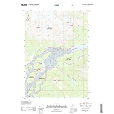
2017 Map of Petersburg C-1 NW
USGS Topo · Published 2017About this map
The Stikine River delta dominates this landscape within the Tongass National Forest, showing a complex network of braided channels and silty deposits. A striking geological transition occurs where the high peaks of Mt Basargin and the Popof Glacier give way to the low-lying glacial outwash plains. An unusual feature known as The Desert sits between Andrew Slough and the main river channel, representing a massive accumulation of river sediment. This survey documents the shifting aquatic environment surrounding Andrew Island and Limb Island, where numerous waterways like Andrew Cr and N Arm Cr carve through the temperate rainforest. The map captures the boundary between the Petersburg Borough and Wrangell, marking a remote wilderness where landforms like Kakwan Point and Hooligan Point overlook the active river system.
Find a feature on this map
26 named features on this map. Tap any name to fly to it.
Don’t see what you’re looking for? This feature index may not catch every label — zoom into the map to look around manually.
Map Details
Editions of this 2017 Petersburg C-1 NW Map
This is the sole edition of this map. No revisions or reprints were ever made.
Other maps of this area

1948 · Petersburg C-1
USGS Topo · 1:63,360

1948 · Petersburg C-2
USGS Topo · 1:63,360

1951 · Petersburg C-2
USGS Topo · 1:63,360

1952 · Petersburg
USGS Topo · 1:250,000

1953 · Petersburg C-1
USGS Topo · 1:63,360

1960 · Petersburg
USGS Topo · 1:250,000

1961 · Petersburg D-1
USGS Topo · 1:63,360

1961 · Petersburg D-2
USGS Topo · 1:63,360

1994 · Petersburg D-2
USGS Topo · 1:63,360
1995 · Petersburg C-1
USGS Topo · 1:63,360