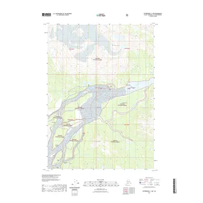
2021 Map of Petersburg C-1 NW
USGS Topo · Published 2021About this map
The Stikine River delta dominates this portion of the Tongass National Forest, revealing a complex network of shifting channels and silt deposits. Notable landforms like The Desert suggest a dynamic fluvial environment where sediment accumulation has created distinct inland features amidst the waterways. Large islands, including Andrew Island, Fifteenmile Island, and Farm Island, partition the river's flow as it approaches the coast, while Andrew Slough and Andrew Cr create secondary drainage patterns to the south.
Find a feature on this map
23 named features on this map. Tap any name to fly to it.
Don’t see what you’re looking for? This feature index may not catch every label — zoom into the map to look around manually.
Map Details
Editions of this 2021 Petersburg C-1 NW Map
This is the sole edition of this map. No revisions or reprints were ever made.
Other maps of this area

1948 · Petersburg C-1
USGS Topo · 1:63,360

1948 · Petersburg C-2
USGS Topo · 1:63,360

1951 · Petersburg C-2
USGS Topo · 1:63,360

1952 · Petersburg
USGS Topo · 1:250,000

1953 · Petersburg C-1
USGS Topo · 1:63,360

1960 · Petersburg
USGS Topo · 1:250,000

1961 · Petersburg D-1
USGS Topo · 1:63,360

1961 · Petersburg D-2
USGS Topo · 1:63,360

1994 · Petersburg D-2
USGS Topo · 1:63,360
1995 · Petersburg C-1
USGS Topo · 1:63,360