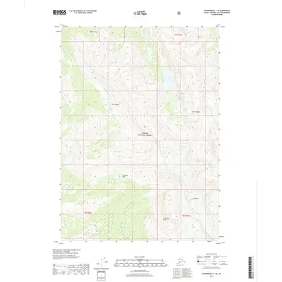
2017 Map of Petersburg C-1 SE
USGS Topo · Published 2017About this map
Tongass National Forest dominates this Alaskan landscape, where glacial activity and drainage patterns define the high-altitude terrain. The presence of the Nelson Glacier in the southeast corner provides a clear indication of the active ice-shaping processes still influencing the region's topography. Two distinct geological depressions, Horseshoe Basin and Groundhog Basin, sit at high elevations, serving as collection points for the seasonal runoff that feeds the complex network of surrounding creeks. A system of fork-fed waterways, including the S Fork Andrew Cr and the N Fork Porterfield Cr, radiates from the central peaks like Mt Waters. This map illustrates the transition from permanent ice fields to the deep-cut creek valleys that characterize the southeastern Alaska wilderness during the early twenty-first century.
Find a feature on this map
16 named features on this map. Tap any name to fly to it.
Don’t see what you’re looking for? This feature index may not catch every label — zoom into the map to look around manually.
Map Details
Editions of this 2017 Petersburg C-1 SE Map
This is the sole edition of this map. No revisions or reprints were ever made.
Other maps of this area

1948 · Petersburg C-1
USGS Topo · 1:63,360

1948 · Petersburg B-1
USGS Topo · 1:63,360

1951 · Bradfield Canal
USGS Topo · 1:250,000

1952 · Petersburg
USGS Topo · 1:250,000

1953 · Petersburg C-1
USGS Topo · 1:63,360

1954 · Bradfield Canal
USGS Topo · 1:250,000

1955 · Bradfield canal C-6
USGS Topo · 1:63,360

1955 · Bradfield canal B-6
USGS Topo · 1:63,360

1955 · Petersburg B-1
USGS Topo · 1:63,360

1955 · Bradfield Canal
USGS Topo · 1:250,000