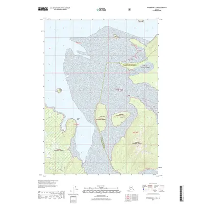
2017 Map of Petersburg C-2 NW
USGS Topo · Published 2017About this map
Tongass National Forest dominates this Alaskan coastal landscape, where the boundary between Petersburg Borough and Wrangell City and Borough meets the sea. The map documents a complex archipelago of islands and inlets, including Pocket Island, Hidden Island, and the larger Dry Island. Coastal navigation and overland access are defined by features such as Cosmos Point and the Mallard Slough Trail near Mallard Slough. To the west, Ideal Cove and the northern reaches of Dry Strait provide protected waters, while the expansive Frederick Sound and Le Conte Bay open toward the horizon. This survey provides a precise view of the region's wilderness character and maritime geography as it stood in the early 21st century.
Find a feature on this map
18 named features on this map. Tap any name to fly to it.
Don’t see what you’re looking for? This feature index may not catch every label — zoom into the map to look around manually.
Map Details
Editions of this 2017 Petersburg C-2 NW Map
This is the sole edition of this map. No revisions or reprints were ever made.
Other maps of this area

1948 · Petersburg C-2
USGS Topo · 1:63,360

1948 · Petersburg C-3
USGS Topo · 1:63,360

1951 · Petersburg C-2
USGS Topo · 1:63,360

1952 · Petersburg
USGS Topo · 1:250,000

1953 · Petersburg C-3
USGS Topo · 1:63,360

1960 · Petersburg
USGS Topo · 1:250,000

1961 · Petersburg D-3
USGS Topo · 1:63,360

1961 · Petersburg D-2
USGS Topo · 1:63,360
1992 · Petersburg C-3 NE
USGS Topo · 1:25,000
1992 · Petersburg C-3 SE
USGS Topo · 1:25,000