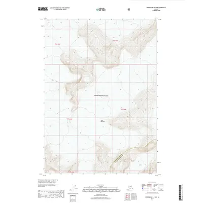
2017 Map of Petersburg D-1 NW
USGS Topo · Published 2017About this map
Tongass National Forest dominates this section of Southeast Alaska, where the high peaks of the Coast Mountains meet massive ice fields. The landscape is defined by the slow movement of glacial ice, with the LeConte Glacier flowing toward the sea in the central portion of the sheet and the Shakes Glacier appearing in the southeast. These frozen rivers have carved deep valleys and steep ridges that dictate the jurisdictional boundaries in this wilderness. The map documents the dividing line between Petersburg Borough and Wrangell Borough, which follows the high drainage divides and ridgelines. For researchers, this survey provides a modern baseline of glacial extent and mountain topography in a region where the terrain is almost entirely shaped by natural forces rather than human development.
Find a feature on this map
5 named features on this map. Tap any name to fly to it.
Don’t see what you’re looking for? This feature index may not catch every label — zoom into the map to look around manually.
Map Details
Editions of this 2017 Petersburg D-1 NW Map
This is the sole edition of this map. No revisions or reprints were ever made.
Other maps of this area

1952 · Petersburg
USGS Topo · 1:250,000

1952 · Sumdum
USGS Topo · 1:250,000

1960 · Petersburg
USGS Topo · 1:250,000

1960 · Sumdum A-1
USGS Topo · 1:63,360

1961 · Sumdum A-2
USGS Topo · 1:63,360

1961 · Petersburg D-1
USGS Topo · 1:63,360

1961 · Petersburg D-2
USGS Topo · 1:63,360

1961 · Sumdum
USGS Topo · 1:250,000

1994 · Petersburg D-2
USGS Topo · 1:63,360
2000 · Petersburg D-1
USGS Topo · 1:63,360