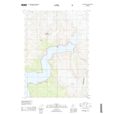
2017 Map of Petersburg D-2 SE
USGS Topo · Published 2017About this map
Le Conte Glacier and its dramatic drainage into the head of Le Conte Bay dominate this coastal Alaskan landscape. Contained within the Tongass National Forest, the region is defined by steep glacial valleys and sharp coastal points. The map details the transition from the ice of the main glacier and the smaller Shakes Glacier in the southeast to the open water of the bay. Notable landmarks like Thunder Point, Timber Point, and the high elevation of Simpson Peak provide critical navigation references in this wilderness area. The survey also captures the administrative boundary between Petersburg Borough and Wrangell Borough, illustrating how these remote jurisdictions meet amidst the ice and fjords.
Find a feature on this map
13 named features on this map. Tap any name to fly to it.
Don’t see what you’re looking for? This feature index may not catch every label — zoom into the map to look around manually.
Map Details
Editions of this 2017 Petersburg D-2 SE Map
This is the sole edition of this map. No revisions or reprints were ever made.
Other maps of this area

1948 · Petersburg C-1
USGS Topo · 1:63,360

1948 · Petersburg C-2
USGS Topo · 1:63,360

1951 · Petersburg C-2
USGS Topo · 1:63,360

1952 · Petersburg
USGS Topo · 1:250,000

1953 · Petersburg C-1
USGS Topo · 1:63,360

1960 · Petersburg
USGS Topo · 1:250,000

1961 · Petersburg D-1
USGS Topo · 1:63,360

1961 · Petersburg D-2
USGS Topo · 1:63,360

1994 · Petersburg D-2
USGS Topo · 1:63,360
1995 · Petersburg C-1
USGS Topo · 1:63,360