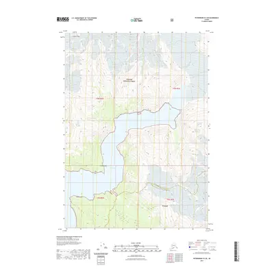
2021 Map of Petersburg D-2 SE
USGS Topo · Published 2021About this map
Le Conte Glacier dominates the northern reaches of this coastal Alaskan landscape, where ice meets the tidal waters of Le Conte Bay. The map documents a dramatic glacial environment within the Tongass National Forest, showing the sharp elevation changes around Simpson Peak and the southern edge of Shakes Glacier. Coastal markers such as Thunder Point and Timber Point define the entrance to the bay, providing critical navigation references in this maritime wilderness. The boundary between Petersburg Borough and Wrangell City and Borough cuts through the terrain, illustrating the modern administrative divisions of this glacier-carved region. The presence of Wrangell in the southern portion suggests the proximity of regional settlement amidst the high-altitude peaks and ice fields.
Find a feature on this map
13 named features on this map. Tap any name to fly to it.
Don’t see what you’re looking for? This feature index may not catch every label — zoom into the map to look around manually.
Map Details
Editions of this 2021 Petersburg D-2 SE Map
This is the sole edition of this map. No revisions or reprints were ever made.
Other maps of this area

1948 · Petersburg C-1
USGS Topo · 1:63,360

1948 · Petersburg C-2
USGS Topo · 1:63,360

1951 · Petersburg C-2
USGS Topo · 1:63,360

1952 · Petersburg
USGS Topo · 1:250,000

1953 · Petersburg C-1
USGS Topo · 1:63,360

1960 · Petersburg
USGS Topo · 1:250,000

1961 · Petersburg D-1
USGS Topo · 1:63,360

1961 · Petersburg D-2
USGS Topo · 1:63,360

1994 · Petersburg D-2
USGS Topo · 1:63,360
1995 · Petersburg C-1
USGS Topo · 1:63,360